Be Local
Eats
/
Bradford
/
Ilkley
→
Retailers - other
Oxfam
Oxfam
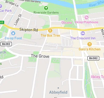
40 The Grove
Ilkley
LS299EE
Food rating: Exempt
Updated:
N/A
Your feedback
+
claim premises
Near Oxfam
Retail Stores
0.1
miles
Clayful
, LS299LB
0.4
miles
★★★★★
Rafis Spricebox
, LS298EE
0.7
miles
Go Express
, LS299DA
0.8
miles
N&K Convenience Store
, LS298NT
4.3
miles
★★★★★
Menston Community Fridge
, LS296HT
4.4
miles
★★★★★
Shans Supermarket
, BD214BY
4.5
miles
Sue Ryder
, BD214AG
4.5
miles
★★★★★
Home Bargins
, BD214AG
Bars & Nightclubs
0.1
miles
★★★★★
The Ticket Office - (Bar Only)
, LS298HF
Restaurants & Cafés
0.1
miles
★★★★★
Clipnclimb
, LS298HF
0.1
miles
★★★★★
Kings Hall Winter Gardens
, LS298HA
0.1
miles
★★★★★
La Stazione
, LS298HF
Supermarkets
0.1
miles
★★★★★
Marks & Spencer - Simply Food
, LS298HF
Chemists
0.1
miles
Boots
, LS298AG
Dentists
0.1
miles
Wells Road Dental Surgery
, LS299JB
0.1
miles
Regent Orthodontics
, LS299EA
Schools
0.7
miles
Moorfield School & Nursery
, LS298RL (117 pupils)
Schools Primary
0.3
miles
All Saints' CofE Primary School
, LS299BE (345 pupils)
0.5
miles
Ashlands Primary School
, LS298JY (318 pupils)
0.6
miles
The Sacred Heart Catholic Primary School
, LS298NL (122 pupils)
Schools Secondary
0.5
miles
Ilkley Grammar School
, LS298TR (2134 pupils)
See all
Retail Stores in Ilkley
.