BLOCLEats

Salvation army - the green

Salvation Army Citadel
217a
Gordon Road
London
SE153RT

Food rating: ★★★★★ 5/5 stars
Updated: 29. May 2024

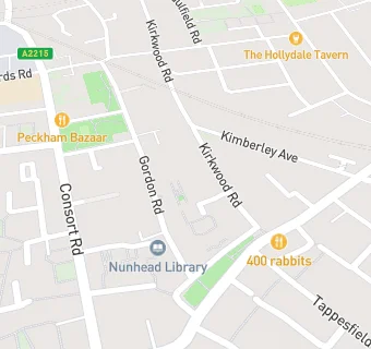
map for Salvation army - the green

Near Salvation army …

  1. Restaurants & Cafés
  2. 0.1 miles ★★★★★The green, SE153QQ
  3. 0.1 miles Wildes deli limited, SE153QQ
  4. 0.2 miles ★★★★★The hollydale tavern, SE152TF
  5. 0.2 miles ★★★★Kudu grill ltd, SE153TR
  6. 0.3 miles ★★★★★The flygerians, SE154PB
  7. 0.3 miles ★★★★★Voodoo ray's, SE154UA
  8. 0.3 miles ★★★★Bus cafe, SE153SU
  9. 0.4 miles ★★Neighbourhood cafe, SE153SN
  10. Care Facilities
  11. 0.2 miles ★★★★★Kairos, SE153LF
  12. Manufacturers
  13. 0.2 miles Osg water ltd, SE152AG
  14. Catering Services
  15. 0.1 miles ★★★★Licked, SE153QQ
  16. Bars & Nightclubs
  17. 0.1 miles ★★★★★Old nuns head, SE153QQ
  18. Retail Stores
  19. 0.2 miles Sauna social club, SE152AG
  20. Takeaway Shops
  21. 0.2 miles Tiktrendmart ltd, SE152DY
  22. Chemists
  23. 0.1 miles Sheel Pharmacy, SE153QF
  24. 0.1 miles Kristal Pharmacy, SE153HB
  25. Schools Primary
  26. 0.2 miles St Mary Magdalene Church of England Primary School, SE153RA (100 pupils)
  27. 0.2 miles Rye Oak Primary School, SE153PD (275 pupils)
  28. 0.3 miles Hollydale Primary School, SE152AR (148 pupils)
  29. 0.4 miles Bellenden Primary School, SE154JP (214 pupils)
  30. Schools Secondary
  31. 0.3 miles The St Thomas the Apostle College, SE152EB (1101 pupils)