BLOCLEats

The Anfield Hotel

37 Church Road
Liverpool
L45TX

Food rating: ★★★★★ 5/5 stars
Updated: 23. January 2020

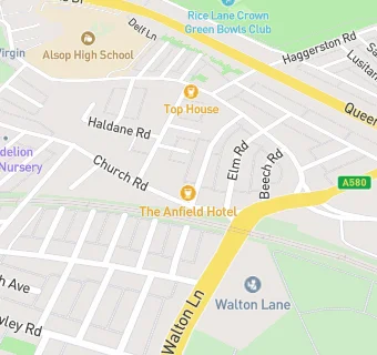
map for The Anfield Hotel

Near The Anfield …

  1. Bars & Nightclubs
  2. 0.1 miles ★★★★★Taxi Club, L46UF
  3. 0.1 miles ★★★★★Top House, L46TN
  4. 0.1 miles ★★★★★Walton Social Club, L45TX
  5. 0.3 miles ★★★★★The Black Horse, L45PW
  6. 0.3 miles ★★★★Crofts Social Club, L45TE
  7. 0.4 miles ★★★★★The Winslow Hotel, L44EH
  8. 0.4 miles ★★★★★The Harlech Castle, L43QD
  9. 0.4 miles ★★★JT'S Bar, L43QA
  10. Care Facilities
  11. 0.1 miles ★★★Oakmere Substance Rehabilitation, L46UG
  12. Restaurants & Cafés
  13. 0.1 miles Eden Village, L46TL
  14. Retail Stores
  15. 0.1 miles Go Local (Haggerston Minimart), L46TT
  16. 0.1 miles Eisas News & Booze, L45UF
  17. Takeaway Shops
  18. 0.1 miles ★★★★★The Chef, L46TT
  19. Chemists
  20. 0.1 miles Coleman And Leighs Pharmacy, L46TH
  21. Doctors
  22. 0.1 miles Walton Village Medical Centre, L46TW
  23. 0.1 miles Walton Village Medical Centre, L46TW
  24. Schools Primary
  25. 0.3 miles Gwladys Street Primary and Nursery School, L45RW (451 pupils)
  26. 0.3 miles Arnot St Mary CofE Primary School, L44ED (461 pupils)
  27. 0.4 miles St Francis de Sales Catholic Infant and Nursery School, L43RX (411 pupils)
  28. 0.5 miles St Francis de Sales Catholic Junior School, L43RL (469 pupils)
  29. Schools Secondary
  30. 0.2 miles Alsop High School, L46SH (1490 pupils)