BLOCLEats

The Angel

THE ANGEL 3 CHURCH STREET
WESTBURY
BA133BY

Food rating: ★★★★★ 5/5 stars
Updated: 7. December 2023

Food ratings

  • Confidence in management: 5
  • Hygiene: 5
  • Structural: 5
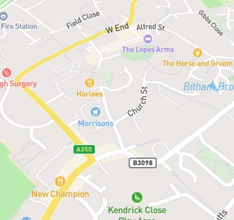
map for The Angel

Near The Angel

  1. Bars & Nightclubs
  2. 0.1 miles ★★★★★Westbury Labour Club, BA133HA
  3. 0.2 miles ★★★★★Westbury Conservative Club, BA133DY
  4. 0.2 miles ★★★★★Horse & Groom, BA133DY
  5. 0.2 miles ★★★★★The Crown Inn, BA133DE
  6. 0.3 miles Ludlow Arms Public House, BA133AX
  7. 0.6 miles ★★★★★Railway Inn, BA134HW
  8. 1.0 mile ★★★★★The Hollies, BA133SF
  9. 1.2 miles ★★★★The View Westbury,
  10. Chemists
  11. 0.1 miles Boots, BA133BN
  12. Dentists
  13. Dentalcare Westbury, BA133DR
  14. 0.1 miles Dumbledore Dental Care Ltd, BA133BW
  15. Restaurants
  16. ★★★★Westbury Pizza Ltd, BA133DR
  17. 0.1 miles ★★★★★Cinnamon Lounge, BA133BW
  18. 0.1 miles ★★★★★Eastern Paradise, BA133PD
  19. 0.1 miles ★★★★★Harlees Fish & Chips Ltd, BA133BN
  20. Retail Stores
  21. 0.1 miles ★★★★★Parsons Bakery Ltd, BA133BW
  22. Supermarkets
  23. ★★★★★Wm Morrison Supermarkets Limited, BA133BQ
  24. Schools
  25. 0.4 miles Compass Community School Athelstan Park, BA133BR (12 pupils)
  26. Schools Primary
  27. 0.4 miles Bitham Brook Primary School, BA133UA (399 pupils)
  28. 0.4 miles Westbury Infant School, BA133NY (213 pupils)
  29. 0.6 miles Westbury Church of England Junior School, BA133LY (262 pupils)
  30. Schools Secondary
  31. 0.3 miles Matravers School, BA133QH (915 pupils)
  32. Takeaway Shops
  33. ★★★★★Bees Cafe, BA133DR