BLOCLEats

The Bowling Green

Friary Road
Lichfield
Staffordshire
WS136QJ

Food rating: ★★★★ 4/5 stars
Updated: 19. June 2024

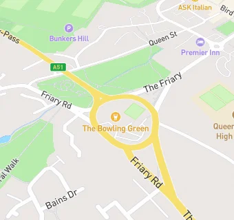
map for The Bowling Green

Near The Bowling …

  1. Bars & Nightclubs
  2. 0.2 miles★★★★★Lichfield Conservative Club, WS136PG
  3. 0.2 milesQueens Head, WS136QD
  4. 0.3 miles★★★★★Angel Inn, WS136LH
  5. 0.3 miles★★★★★Walkabout, WS136PW
  6. 0.3 miles★★★Brewhouse & Kitchen, WS136PW
  7. 0.3 miles★★★★★Horse & Jockey, WS136QA
  8. 0.3 miles★★★Paradise, WS136QA
  9. 0.3 miles★★★★★The Kings Head Pub, WS136PW
  10. Hotels & BnBs
  11. 0.2 miles★★★★★Lichfield City Centre Premier Inn, WS136QZ
  12. Restaurants & Cafés
  13. 0.1 miles★★★★★Perry's Fine Foods, WS136FG
  14. 0.2 miles★★★★★Lichfield Coffee Shop, WS136QG
  15. 0.2 miles★★★★★Queen Of The Forest, WS136JN
  16. 0.3 miles★★★★★Eastern Eye, WS136PW
  17. School Food Ratings
  18. 0.2 miles★★★★★Queens Croft High School, WS136PJ
  19. Takeaway Shops
  20. 0.3 miles★★★★★Domino's Pizza, WS136NU
  21. 0.3 miles★★★Lichfield House, WS136QA
  22. Schools
  23. 0.2 milesQueen's Croft High School, WS136PJ (196 pupils)
  24. 0.5 milesLichfield Cathedral School, WS137LH (571 pupils)
  25. Schools Primary
  26. 0.4 milesChrist Church CofE (C) Primary School, WS138AY (426 pupils)
  27. 0.6 milesSt Joseph's Catholic Primary School, WS149AN (210 pupils)
  28. Schools Secondary
  29. 0.6 milesKing Edward VI School, WS149EE (1630 pupils)

See all Bars & Nightclubs in Lichfield.