BLOCLEats

The Crown

10 All Saints Lane
City Centre
Bristol
BS11JH

Food rating: ★★★★★ 5/5 stars
Updated: 25. October 2024

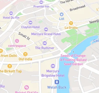
map for The Crown

Near The Crown

  1. Bars & Nightclubs
  2. ★★★★The Rummer, BS11JH
  3. ★★★★★Seamus O'Donnells, BS11UE
  4. ★★★★★The Boardroom, BS11UB
  5. 0.1 miles★★★★★Milkthistle, BS11EA
  6. 0.1 miles★★★★★White Lion Hotel, BS11EB
  7. 0.1 miles★★★★★London Cocktail Club, BS11HT
  8. 0.1 miles★★★★★The Bank Tavern, BS12HR
  9. 0.1 miles★★★★★Walkabout, BS11HQ
  10. Food Trucks
  11. ★★★★Maya Bakery, BS11JQ
  12. Catering Services
  13. ★★★★★Royce Rolls, BS11JQ
  14. Restaurants & Cafés
  15. ★★★★★Cafe Atlas, BS11LJ
  16. ★★★★Big Juice Ltd, BS11JQ
  17. ★★★★★Daily Noodles, BS11JQ
  18. Retail Stores
  19. ★★★★★Kalahari Moon, BS11JQ
  20. Red Tiger, BS11JQ
  21. Takeaway Shops
  22. ★★★Caribbean Wrap, BS11LJ
  23. Schools Nursery
  24. 0.6 milesRosemary Nursery School and Children's Centre, BS20DT (72 pupils)
  25. Schools Primary
  26. 0.3 milesWillow Park CofE Primary School, BS28BE (127 pupils)
  27. 0.4 milesCathedral Primary School, BS15TS (422 pupils)
  28. Schools Secondary
  29. 0.4 milesBristol Cathedral Choir School, BS15TS (1167 pupils)
  30. 0.6 milesSt Mary Redcliffe and Temple School, BS16RT (1759 pupils)

See all Bars & Nightclubs in Bristol.