BLOCLEats

The National Trust

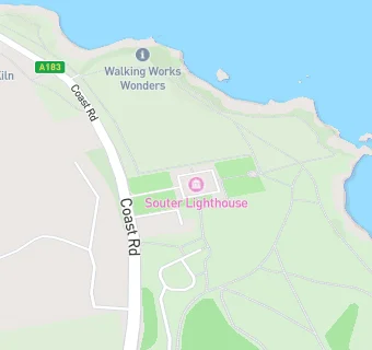
Souter Lighthouse
Coast Road
Whitburn
Tyne & Wear
SR67NH

Food rating: ★★★★★ 5/5 stars
Updated: 23. September 2024

map for The National Trust

Near The National …

  1. Restaurants & Cafés
  2. 0.5 miles ★★★★★Hillhead Farm Shop & Tea Room, SR67NN
  3. 1.2 miles Betty's Homemade Treats, NE347RL
  4. 1.4 miles ★★★★★The Village Cafe, SR67JB
  5. 1.4 miles ★★★★Mamma Mia Whitburn, SR67BX
  6. 1.4 miles ★★★★★Tutti Frutti, SR67BX
  7. 1.4 miles ★★★★★Barnes Institute, SR67BY
  8. 1.4 miles ★★★★★Brambles Court, NE347JA
  9. 1.4 miles ★★★★eaststreet 19, SR67BY
  10. Care Facilities
  11. 0.6 miles ★★★★★Breakfast Club, SR67HJ
  12. Bars & Nightclubs
  13. 0.4 miles ★★★★★Whitburn Golf Club Ltd, NE347AF
  14. 0.7 miles ★★★The Grotto, NE347BS
  15. 0.9 miles ★★★★★The Lake, NE347AY
  16. Retail Stores
  17. ★★★★★The Leas Kiosk - Velvet Beds, SR67NH
  18. 0.7 miles ★★★★★Lizard Lane Caravan Park, NE347AB
  19. 0.8 miles ★★★★Simars News - Best Buy, SR67HB
  20. School Food Ratings
  21. 0.6 miles ★★★★★Marsden Primary School, SR67HJ
  22. Schools Primary
  23. 0.6 miles Marsden Primary School, SR67HJ (222 pupils)
  24. 1.5 miles Harton Primary School, NE346PF (684 pupils)
  25. 1.5 miles Whitburn Village Primary School, SR67NS
  26. Schools Secondary
  27. 1.2 miles Whitburn Church of England Academy, SR67EF (1239 pupils)
  28. 1.7 miles Harton Academy, NE346DL (1659 pupils)