BLOCLEats

The Salvation Army

Church Street
Clowne
Chesterfield
S434JS

Food rating: ★★★★★ 5/5 stars
Updated: 20. November 2024

Food ratings

Confidence in management: 5
Hygiene: 5
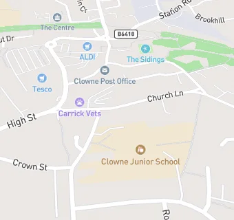
map for The Salvation Army

Near The Salvation …

  1. Catering Services
  2. 0.3 milesClowne Methodist Church, S434PF
  3. 1.4 miles★★★★★Wendys, S434WP
  4. 1.5 milesBarlborough Church Institute, S434EP
  5. 1.9 miles★★★★★Creswell Events Centre, S804BH
  6. 1.9 miles★★★★★Izzys Cakes And Bakes, S804WN
  7. 2.0 miles★★★Limestone House & Food Bank, S804JE
  8. 2.3 miles★★★★★Coloured Cob Trekking Centre Ltd, S804AA
  9. 2.4 miles★★★★★Whitwell Community Centre, S804NN
  10. Care Facilities
  11. 0.1 miles★★★★★Children 1st @ Breedon House, S434JX
  12. Restaurants & Cafés
  13. 0.1 miles★★★★★Tesco Cafe, S434LJ
  14. Retail Stores
  15. 0.1 miles★★★★★Candy Palace, S434JN
  16. 0.1 miles★★★★★Oven Door, S434JN
  17. Takeaway Shops
  18. 0.1 miles★★★★★Sea Blue Fisheries, S434JJ
  19. 0.1 milesMughal Kashmir, S434JN
  20. 0.1 miles★★★★★Peri Pollo Pizza, S434JN
  21. Chemists
  22. 0.1 milesTesco Instore Pharmacy, S434JN
  23. Schools
  24. 0.3 milesNew Direction, S434BX (26 pupils)
  25. Schools Primary
  26. Clowne Infant and Nursery School, S434DB (314 pupils)
  27. 0.1 milesClowne Junior School, S434BS (338 pupils)
  28. 1.6 milesBarlborough Primary School, S434ET (199 pupils)
  29. Schools Secondary
  30. 0.4 milesHeritage High School, S434QG (993 pupils)

See all Catering Services in Clowne.