BLOCLEats

The Salvation Army

Westow Street
Upper Norwood
London
SE193AF

Food rating: ★★★★★ 5/5 stars
Updated: 15. May 2023

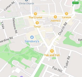
map for The Salvation Army

Near The Salvation …

  1. Restaurants & Cafés
  2. ★★★★★La Bruschetta, SE193RW
  3. ★★★★★Mi Cocina Es Tuya, SE193RW
  4. ★★★★★The Triangle, SE193BG
  5. ★★★★★Urban Orient, SE193AF
  6. 0.1 miles★★★Tofu, SE193RY
  7. 0.1 miles★★★★★Yak & Yeti Restaurant, SE192PR
  8. 0.1 miles★★★★Timur, SE193RY
  9. 0.1 miles★★★★★Alistairs American Diner, SE193RY
  10. Hotels & BnBs
  11. 0.1 miles★★★★★Stay Belvedere Hotels (SBHL), SE192UG
  12. Catering Services
  13. Pheonix Community Association, SE193AF
  14. 0.1 miles★★★★★AM Coffee Limited, SE192TA
  15. Bars & Nightclubs
  16. ★★★★★The White Hart, SE192EZ
  17. Retail Stores
  18. ★★★★★Blackbird Bakery, SE193RW
  19. ★★★★★Kims Newsagent, SE193RW
  20. 0.1 miles★★★★Poundland, SE193AF
  21. Supermarkets
  22. ★★★★★Sainsbury's, SE193AF
  23. Schools
  24. 0.4 milesHillcrest, SE191BY
  25. Schools Primary
  26. 0.3 milesPaxton Primary School, SE191PA (462 pupils)
  27. 0.4 milesRockmount Primary School, SE193ST (451 pupils)
  28. 0.4 milesAll Saints CofE Primary School, SE193LG (243 pupils)
  29. Schools Secondary
  30. 0.5 milesHarris City Academy Crystal Palace, SE192JH (1258 pupils)

See all Restaurants & Cafés in Croydon.