- Blocl
- Schools
- County of Flintshire
- Mold
The Lighthouse School
closed
Your feedback +
Welsh establishment
- URN
- 401981
- Establishment type
- Welsh establishment
- Establishment #
- 6001
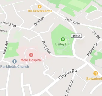
- OSGB coordinates
- Easting: 323462, Northing: 364250
- GPS coordinates
- Latitude: 53.170, Longitude: -3.1464
- Region › Const. › Ward
- Wales › Delyn › Mold West
Schools nearby
- The Lighthouse School,
CH71RA
-
0.3
miles Ysgol Bryn Gwalia C.P.,
CH71SU
-
0.4
miles Ysgol Glanrafon,
CH71PS
-
0.4
miles Ysgol Bryn Coch C.P.,
CH71EW
-
0.5
miles St David's R.C. School,
CH71LH
-
0.5
miles Ysgol Delyn,
CH71HJ
-
0.6
miles Mold Alun School,
CH71EP
-
0.6
miles Ysgol Maes Garmon,
CH71JB
-
0.9
miles Oakwood Small School,
CH74AE
-
1.3
miles Gwernymynydd C.P. School,
CH74DT
-
1.5
miles Mynydd Isa Junior School,
CH76SJ
-
1.5
miles Sychdyn C.P. School,
CH76ED
-
1.6
miles Wat's Dyke Infants School,
CH76UL
-
1.8
miles Argoed High School,
CH76RY
-
1.9
miles Ysgol Y Waun,
CH75DP
-
2.1
miles Nercwys CIW Voluntary Aided Primary School,
CH74EW
-
2.3
miles Buckley Southdown C.P.,
CH72NP
-
2.5
miles Galn Alyn Boarding School,
CH75LB
-
2.6
miles Westwood Community Primary School,
CH72JT
-
2.6
miles Elfed High School,
CH73HQ
-
2.7
miles Ysgol Y Ddol,
CH75HW
-
2.7
miles Ysgol Owen Jones C.P.,
CH76AU
-
2.7
miles Ysgol Belmont,
CH73HA
-
3
miles Mountain Lane C.P. School,
CH73JA
-
3.2
miles Northop Hall C.P. School,
CH76HS
🚸
schools in Mold