BLOCLEats

Rising Sun\*

Rising Sun Inn
Coast Road
Wallsend
Tyne And Wear
NE289HP

Food rating: ★★★★★ 5/5 stars
Updated: 5. December 2019

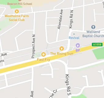
map for Rising Sun\*

Near Rising Sun\*

  1. Bars & Nightclubs
  2. 0.2 miles ★★★★★Westholme Farm Social Club, NE289LH
  3. 0.4 miles ★★★★★The Barking Dog, NE289JJ
  4. 0.4 miles ★★★★★Wallsend Ex Servicemen And Working Mens Club And Institute, NE288DG
  5. 0.6 miles ★★★★★The Miner's Club And Bella Carvery, NE288RG
  6. 0.6 miles ★★★★★The Powder Monkey, NE288TU
  7. 0.6 miles ★★★★★Lindisfarne Social Club Ltd, NE288LG
  8. 0.7 miles ★★★★★The Anson, NE288QS
  9. 0.7 miles ★★★★★Coronation Club, NE287LW
  10. Food Trucks
  11. 0.1 miles ★★★★★John's Ice's MW12 VFE, NE287QQ
  12. Retail Stores
  13. Coast Road Pharmacy, NE289HP
  14. ★★★★★One Stop, NE289HP
  15. 0.1 miles ★★★★★Bluesign Londis, NE289HS
  16. Takeaway Shops
  17. ★★★Porky's/A And S Buffets, NE289HP
  18. ★★★★★The Mandarin, NE289HP
  19. Fast Fry, NE289HP
  20. Chemists
  21. Coast Road Pharmacy, NE289HP
  22. Schools
  23. 0.3 miles Beacon Hill School, NE289JW (232 pupils)
  24. Schools Primary
  25. 0.3 miles St Bernadettes Catholic Primary, Wallsend, NE289JW (318 pupils)
  26. 0.4 miles Wallsend Jubilee Primary School, NE289HA (384 pupils)
  27. 0.5 miles St Columba's Catholic Primary School, Wallsend, NE288EN (210 pupils)
  28. 0.6 miles Redesdale Primary School, NE288TS (335 pupils)