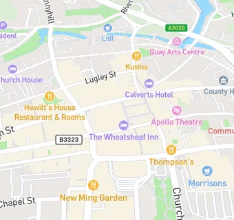
BLOCLEats

Wheatsheaf Hotel

16 St Thomas Square
Newport
Isle Of Wight
PO301SG

Food rating: ★★★★★ 5/5 stars
Updated: 21. September 2023

map for Wheatsheaf Hotel

Near Wheatsheaf Hotel

  1. Bars & Nightclubs
  2. ★★★★★Newport Conservative Club, PO301XB
  3. 0.1 milesPrince Of Wales, PO301JE
  4. 0.1 miles★★★★★Craft Catering, PO305ET
  5. 0.1 milesStrings Bar \& Venue, PO301RR
  6. 0.1 milesThe Celt, PO301SS
  7. 0.1 miles★★★★★Slug \& Lettuce, PO301SS
  8. 0.1 miles★★★★The Castle Inn, PO301BQ
  9. 0.1 miles★★★★★Southern Vectis Social Club, PO301JE
  10. Catering Services
  11. ★★★★★Independent Arts, PO301SE
  12. ★★★★★Newport Minster, PO301SG
  13. Restaurants & Cafés
  14. ★★★★★Papa P's, PO301SG
  15. Retail Stores
  16. Lloyds Pharmacy, PO301XB
  17. TK Maxx, PO301XB
  18. ★★★★★Holland And Barrett, PO301SE
  19. Clinton Cards, PO301SE
  20. Chemists
  21. Boots, PO301TP
  22. Schools
  23. 0.4 milesMedina House School, PO302HS (107 pupils)
  24. Schools 16 Plus
  25. 0.5 milesThe Isle of Wight College, PO305TA
  26. Schools Primary
  27. 0.4 milesBarton Primary School, PO302AX (257 pupils)
  28. 0.4 milesNine Acres Primary School, PO301QP (409 pupils)
  29. 0.5 milesNewport Church of England Aided Primary School, PO305GD (299 pupils)

See all Bars & Nightclubs in Newport.